Residents of the Central Coast have until 1 March to comment on a new generic plan of management that will cover 400 community land sites but public calls for more transparency from council are getting louder.

By Jacquelene Pearson
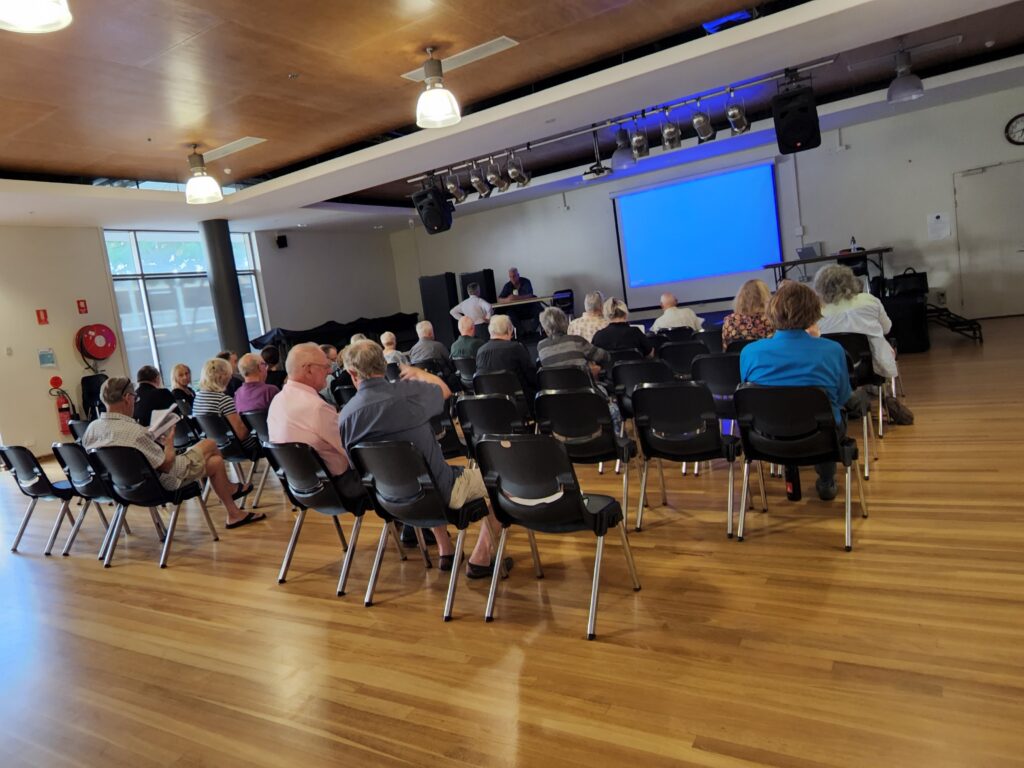
Five ‘public hearings’ have been held at Wyong, Erina and Woy Woy to give residents and ratepayers the opportunity to provide feedback on Central Coast Council’s draft plan of management for 400 of its community landholdings. Chris Barrett, Manager of Commercial Property and Airports at Central Coast Council, went to great pains at the Erina public hearing on February 6 to clarify that the process was “not about selling community land”.
To reinforce that message, later in the same public hearing the independent chair, consultant Carl Malmberg, attempted to placate members of the public by emphasising that land owned by a council that is classified as community land cannot be sold.
“You need to pass that on to council. If they are trying to sell community land it is not legal to do so. Community land is not available for sale,” Malmberg said. However, community campaigners Joy Cooper and Sue Chidgey pointed out that Central Coast Council currently had community land in Mann St, Gosford, for sale, pending its reclassification from community to operational land.
If community members accept that the purpose of the draft plan of management is not to reclassify community land to sell it off, then they may also have heard multiple reasons for the council’s decision to exhibit and adopt a new plan of management while under administration.
Those reasons include: a simple administrative housekeeping exercise to bring old plans up to date and have consistent rules across the two former local government areas; the need to categorise land that has come into council ownership but not given a plan of management; to make sure the category given to a piece of community land matches its day to day uses; or to give certainty to community groups who are unable to enter binding leases because the facilities they wish to use have not been classified under a plan of management. Perhaps all these reasons are relevant.
Those who have attended the public hearings have learned that plans of management have a specific meaning under the Local Government Act, that the public hearings are a legal requirement and they must be facilitated by an independent chair. We’ve also been informed that the hearings are recorded and the consultants acting as chair will prepare a report which Council must make public within four days of receiving it.
We were informed that this is not a new project. It has been in play for three years, commencing in 2019 when a committee was formed to start assessing every parcel of public land owned by Central Coast Council, examine its plan of management and determined whether or not it was still relevant, so it has basically been a modernising exercise and the public consultation is the final stage. Council wants this project wrapped up by May.
If, as a result of the public feedback, council finds its classification of a particular parcel of land needs to change it will do so, the Erina public hearing was informed. Pieces of land that cannot be categorised in the current process will remain unclassified and another round of hearings may be held towards the end of the year.
The task is huge: 2400 individual lots of land have been amalgamated into 400 sites. Of those, 200 sites will have no change to their current classifications. Another 100 are being classified for the first time and a further hundred are being reclassified.
The facts about this process
Residents attending the public hearings were told to focus on providing feedback about those 200 sites that were either being classified for the first time or reclassified. General comments, they were told, should be saved for when they write their submissions. However, members of the public were clearly confused by the process and were seeking answers to basic questions such as the difference between a land’s classification and its zoning and why a suburb like Point Clare was dealt with at a public hearing located in Wyong while nearby Tascott and Koolewong were part of the Woy Woy hearing.
There were no microphones provided at the public hearings and council’s mapping system crashed at the Woy Woy hearing on February 7 rendering it impossible to fulfil the main purpose of the hearing which was to look at individual lots of land via the council’s digital mapping system.
All land owned by a council in NSW is described as public land and it must be categorised as either operational land or community land. Operational land is basically at the disposal of the council and includes their depots. It can be sold without community consultation.
Community land is special and considered of enough value to the community to be kept and managed for perpetuity. All community land must be subject to a plan or plans of management and must be classified as: general use, sports ground, park or natural area. Natural areas are further sub-categorised into bushland, wetland, escarpment, watercourse or foreshore.
Although they have not explained it very well, the Central Coast Council wants residents to go to the www.yourvoiceourcoast.com website, look at the schedule of community land that has been published there. Look in particular at the community land sites in their local area or that they have knowledge of and provide feedback to council about whether or not the classification chosen by council staff for any particular piece of land is accurate.
It has been clear from the public hearings that community members have substantial knowledge about the history, features and use of community land in their local areas. It is clear that they are not always in agreement with Central Coast Council about the way land has been categorised.
For example, over 100 lots of Natural Area Bushland or Wetland have been recategorised in the draft plan of management to Park or General Use. Clearly the core objectives for the management of land classified as general use or park are significantly different to the core objectives for the management of bushland or a wetland. Members of the public mused over how a wetland can suddenly become a park.
Former Mayor Jane Smith asked for more information about the classification of land on Blackwall Mountain, a significant amount of Natural Area – Bushland on the Woy Woy Peninsula. Smith asked whether the decision to classify lots on Blackwall Mountain as General Community Use were based on a desktop review of ground truthing, “and what is the process to decide on those three categorisations instead of one?” she asked.
The general answer given was that council in 2019 set up a committee with representatives for environmental land, open space, facilities, water and sewerage “and they sat down and went through the entire list of parcels of land and looked at it and relied on a mixture of desktop assessment…things like flooding studies, things like vegetation studies, They also relied on the expert knowledge of individual staff officers.” but they did not visit every site.
Smith asked: “I am consciously asking for a proactive release of that information so we can look at it and decide why it was made that category.”
Sue Ellis of the Ettymalong bushcare group commented that the existing Blackwall Mountain Plan of Management contains “detailed information including the fact there are no toilet facilities there…and also things like monitoring for threatened species. So all that detail is lost by having an overarching management plan [for all 400 sites across the Coast],” she said.
Ellis said the community had contributed to existing plans of management which have acted as an “incredible resource”.
“Community input into existing management plans and they act as an incredible resource. “If you have a natural area and students come in the first thing they go to is the plan of management. Resource available to the community as well as to view the quality of management applied to those areas.”
The public hearings were restricted to an hour and a half and each set out to look at pages of individual lots and DPs. The community was told to save their general comments and questions for their submissions.
The bottom line is that if you have a natural reserve, wetland, foreshore area, park or sportsfield near your home that you care about, it is worth checking how it will be classified under Central Coast Council’s proposed new plan of management.
Here’s how to find out and have your say.
Step 1 – visit www.yourvoiceourcoast.com and go to the tab that is called DRAFT PLAN OF MANAGEMENT FOR COUNCIL COMMUNITY LAND
Step 2 – there are multiple elements to this consultation. You have the opportunity to comment on the draft plan of management via a submission. There is also a schedule of community land and a series of maps. Open the schedule of community land and look up the locations you are interested in. If there is a YES in the column ‘New or Recategorised’ you will need to check that the category chosen by council staff is appropriate.
Step 3 – Use Six Maps to check whether you agree with council’s classification. Place the lot and DP shown on the land schedule into the six maps search tab or the street address. Six Maps will give you an aerial view of the land in question and you can easily zoom in to see its characteristics.
Step 4 – if you disagree with councils classification, use the submission form on the yourvoiceourcoast page and detail your comments about that individual block
If you do not have access to a computer or the internet Central Coast Council has made paper copies of all the documents you need available at each of its library branches.
In addition to making comments about individual lots or sites, you can also send the council a submission providing feedback on its plan of management. For instance, do you agree that all 400 sites should be covered by a generic plan of management?
The Point will continue to report on this issue.


