
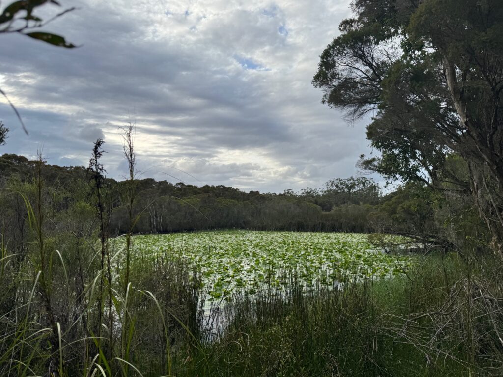
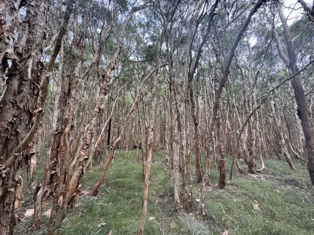
The old timers call it Porters Lake because it resembles a massive lake when flooded – a sight to behold. But over recent decades Porters Creek Wetland has been suffering death by a thousand cuts. A promised Biodiversity Stewardship Agreement may change that for the better, or it may not.
By Jacquelene Pearson
If you’ve caught the train between Sydney and Newcastle you’ve passed Porters Creek Wetland, but you probably thought it was just another patch of scrubby native bush along the main northern rail line. It is located between Watanobbi, near Wyong in the south and Warnervale in the north. From east to west, it takes up the area between the northern rail line and Jilliby near the M1 Motorway.
Small remnant sections of the wetland can be found west of the M1 and east of the railway. It clearly would’ve covered a much larger area “back in the day”.
Porters Creek Wetland is the largest of the surviving freshwater wetlands in the NSW Central Coast region. During the Millennial Drought (1996-2010) the local councils were gearing up to use the wetland as an alternative drinking water supply.
According to Central Coast Council, the wetland drains to the Wyong River, which makes its way to Tacoma where it enters the ninth largest coastal lake system in NSW, Tuggerah Lakes.
“As a filter of stormwater from the catchment, it acts as a kidney for Tuggerah Lakes. It is also significant for flood mitigation for the lower Wyong River,” according to Central Coast Council.
“Porters Creek Wetland is significant due to its size (at least 700 hectares), its rare and endangered swamp forest communities and its high species diversity including a number of threatened flora and fauna species,” the council’s website explains.
“It includes five Endangered Ecological Communities (EECs) listed under the Biodiversity Conservation Act 2016 and has high conservation value.
The council notes that one species living in the wetland is the vulnerable wallum froglet. The writer has seen multiple species of rare native orchids in the wetland.
“The Aboriginal Heritage Information Management System register indicates that there are 15 known Aboriginal Places on, or near, the Conservation Area.”
It’s a special place.
Threats
Central Coast Council’s presentation to the NSW Coastal Conference back in 2019 gave some insight into the importance of Porters Creek Wetland to the health of the Tuggerah Lakes.
“The loss of natural filters including wetlands and saltmarshes has taken away the catchment’s capacity to self-cleanse, like removing the kidneys of the estuary, filling and clearing of those important vegetation communities has a major impact on the downstream health.
“More hard surfaces mean water can’t filter down into the ground and instead it runs quickly through channels and drains overland picking up lots of urban pollutants as it goes. The major pollutants include nutrients and sediment and gross pollutants such as gravel, litter and plastics.”
Modelling shows that the largest volume of pollutants still comes from the rural parts of the catchment but the most damaging comes from the ever-expanding urban areas.
Porters Creek Wetland is supposed to filter the water before it reaches Wyong River and the lakes. But Porters Creek Wetland is under pressure from multiple threats, including over-development in the catchment, sub-optimal stormwater management and expansion plans at the neighbouring Central Coast Airport.
Storm water
According to the report from the NSW Government-appointed Tuggerah Lakes Expert Panel, scientific studies identified that urban stormwater is a key contributor to current poor water quality and the degradation of catchment waterway and wetland health, through increased pollutant loads and changes to natural flow regimes.
“Substantial areas of future development in the Porters Creek catchment drain to Porters Creek Wetland, a wetland of state significance that provides an important water quality buffer to Tuggerah Lakes,” The TLEP report said.
One of the over-arching conclusions of the TLEP report was that “current development planning controls do not ensure that the future water quality in Tuggerah Lakes will be maintained or improved”.
It said that the Tuggerah Lakes system was at a crossroads. Even so, the NSW Government’s Central Coast Regional Plan 2041 earmarked nearby Warnervale for massive population growth over the next 15 years.
The TLEP said action was needed to protect the Tuggerah Lakes catchment, including Porters Creek Wetland.
The TLEP recommended the development of “a stormwater management plan and integrated water management plan for Porters Creek Wetland to help monitor its ongoing performance during increased development activities”.
Its other recommendations included the formation of a Catchment Coordinator Taskforce for a five-year period, with review after three years, to assist in implementing the recommendations of their review.
It also called for measures such as an independent audit of water-sensitive urban design practices, the introduction of consistent standards for water sensitive urban design requirements for all infrastructure works, and more training on these for council staff.
Those recommendations were made in October 2022.
Asking for answers
From February 2019 until June 2023, there was a standing item in the ‘Action Log’ that was appended to the minutes of the Central Coast Council’s Catchment to Coast Advisory Committee.
The committee’s requested action was “a presentation on the Stormwater Management Plan currently under review for the Porters Creek Wetland catchment”.
In December 2021, staff responded that no further updates were available and that they were “Proceeding with trying to get costing prepared for options”.
Again in March 2022, “No further update – cost estimate of works underway”.
In May 2022, “No further update – cost estimate of works is still underway. Investigation regarding funding nexus, Dev. Contributions Plan, revegetation strategy”.
In November 2022, staff reported to the advisory committee that, “Council has recently completed the Porters Creek Wetland & Catchment Stormwater Modelling, Revegetation Plan and Monitoring Plan (Cardno 2022).
“The plan shows that the proposed revegetation will provide little reduction in stormwater flows entering the wetland from developments. Therefore, Council is currently investigating other potential stormwater management opportunities for the wetland.
“Until such time as a new stormwater management strategy is developed & adopted, all new development will be assessed in accordance with Council’s LEP, DCP and Civil Works Specifications.”
Consultant’s report
In 2020 Central Coast Council secured a $4.7 million Australian Government Environment Restoration Fund grant – a campaign commitment by the Federal Member for Dobell, Emma McBride, in the 2019 federal election.
It was to fund several research projects including a review of the performance of stormwater treatment devices, condition mapping of wetlands and saltmarshes to update information from 2009, among other projects.
The Cardno report, referred to in the Catchment to Coast Committee action log, is not in the public domain even though the advisory committee did receive a presentation with slides.
The lack of transparency around how the council made its decision to abandon the TLEP recommendations makes it difficult to assess whether the report that Central Coast Council paid for from Cardno was more robust and informative than the conclusions of the TLEP.
We cannot quote from the Cardno report, but we can reiterate why the TLEP recommended the need for innovation and expenditure on stormwater management and design excellence in the wetland catchment.
“Recent catchment development does not appear to have been undertaken using best practice for stormwater or urban water quality design. As the developments are not applying best practice, the resulting stormwater quality from these developments has the potential to add toxic pollutants, turbidity, and nutrients.
“Several attempts have been made to treat these inflows using, sometimes quite innovative, water sensitive urban design techniques, but both the magnitude of the problem and the financial costs of maintaining these structures is daunting for any Council.”
Armed with the Cardno report, it appears Central Coast Council decided in 2022 that the magnitude of the problem was beyond their resources and walked away from implementing best practice storm water management and urban design.
The 15 councillors elected in September 2024 voted at their extraordinary meeting of 11 March 2025 to form a new Catchment to Coast Advisory Committee. Perhaps the new committee, when appointed, can be fully briefed on the Cardno report and the current approach to stormwater management in Porters Creek Wetland.
Home sweet home
Greater Warnervale is identified as a major urban growth area in the NSW Government’s Central Coast Regional Plan 2041 and we all know there is a housing crisis in NSW, so the motto of current Premier Chris Minns is “build baby build”.
According to Gary Chestnut, Chair of the Community Environment Network, “You are talking about thousands and thousands of homes” being built in the catchment of the wetland.
“The amount of development that’s currently occurring within the catchment is actually phenomenal.”
And the more natural ground cover replaced with hard-stand concrete, the more difficult it will be for the wetland to survive – particularly without a best practice approach to stormwater management.
“It places the wetland under greater pressure. It is going to be surrounded by more and more development.
“Prior to this the development was actually scattered rural residential development… you had a couple of houses but the majority of the land surface was either pasture or vegetation… so that nutrients were retained on the land; but if it all becomes a hard surface area it means nutrients are no longer absorbed. They all get channeled towards the wetland.
“Within an urban area, they have domestic pets, they have dogs and cats that defecate around the catchment area. All those nutrients end up in the waterways and all end up in Porter’s Creek Wetland.
“Some of the native plants won’t like that extra nutrient level and weeds love it… You have a combination that native flora goes under stress where exotic plants go berserk… You’ll have weed invasion penetrating right across the wetland, which means you’ve got more management problems.”
If these problems are not prioritised and carefully managed, the wetland could die.
Everybody needs good neighbours
It’s not unusual for airports to be located near wetlands but not all airports have the history of the one located at Warnervale. Its name changes regularly for starters. It is technically an Aircraft Landing Area (ALA), known at various times as Warnervale Airport and intermittently as Central Coast Airport.
Between 1996 and 2023, the activities at the airport were restricted by the NSW Warnervale Airport Restrictions Act. The Act was put in place to protect surrounding communities from airport traffic and the accompanying noise.
A byproduct of the WAR Act was it meant the runway could not be extended into the state significant Porters Creek Wetland, located at its southern end.
The majority of the wetland is zoned C2, the highest level of protection that can be given to land in NSW outside of a nature reserve or national park. In fact, the total area of C2 land in council ownership including the wetland and the airport is more than 900 hectares.
According to Gary Chestnut, Porters Creek Wetland is near other nature reserves including Jilliby State Conservation Area.
“Porters Creek Wetland is located in the middle of the wildlife corridor linking Ourimbah State Forest across to the Wyrrabalong National Park, and it is a critical link going up to the north into Lake Macquarie,” Chestnut says. “It’s on the crossroads of wildlife corridors going east, west, north, south.
“Over 90% of the area that council owns consists of endangered ecological communities,” he says.
“Now, this is where you come into the conflicts,” he says. “The airport has what’s called existing use rights.”
The land was originally zoned as rural and that allowed the construction of the original runway. This gives the council and airport operator ongoing rights to slash, mow and trim vegetation that should be conserved.
Chestnut has undertaken a comprehensive review of historical aerial photos of the site to ascertain how the land uses have changed.
The airport originally operated as a grass runway and then it became a paved runway with a length of just over 900m.
Between 2014 and 2016 the Wyong Shire Council extended the runway without following the appropriate approval processes under the Environmental Planning and Assessment Act.
It was fined by the Department of Planning for clearing vegetation without development consent and ordered to rehabilitate the damaged flora. It appears that rehabilitation was never completed even though a resolution by the former councillors remains on the books due to a bungled attempt to rescind it.
According to Gary Chestnut, the Central Coast Council will continue to keep sacrificing the wellbeing of Porters Creek Wetland in favour of developing a general aviation hub at the adjoining airport.
Realignment or rezoning?
Rather than prioritising the conservation of the wetland, Chestnut says the council’s approach to the airport is all about maximising its economic viability.
“To maximise the economic viability of the airport you’ve got to expand the runway,” he says.
“The current landing strip is only suitable for use by single engine aircraft and, to be financially viable, it needs to be suitable for use by larger aircraft,” Chestnut says.
He says a recently-adopted Airport Masterplan proposes the rezoning of C2 land at the southern end of the runway to a Special Purpose zone that would exclude it from a proposal to make the wetland a Conservation Stewardship Site under the NSW Biodiversity Conservation Act.
Chestnut said the proposed Biodiversity Stewardship Agreement is good news for the wetland but he believes it should have been put in place before the airport masterplan was adopted. He is concerned about the damage that can be done in the period between activation of the airport masterplan and implementation of the Stewardship Agreement.
He said he was shocked to hear Mayor Lawrie McKinna claim on ABC radio breakfast that there would be no rezoning of conservation land under the masterplan, just a “re-alignment”.
“We have a local government that just sees flat land and they want to develop it; that is what we’re up against … a culture in the current Central Coast Council that places no value on conservation … I’m talking about the bureaucracy, that unknown animal beast.
“There are individual officers that are passionate about the environment. There’s individual officers that are passionate about development. There’s individual offices that look at balancing environment and development. I’ve got no doubt about that whatsoever. However, the culture of the beast originates from the Wyong Shire Council.
“The Wyong Shire Council in 2014 had a culture of ignoring statutory legal requirements to do a Part 5 assessment before extending the runway.”
Chestnut, who has been an avid recreational pilot himself, says he has “no objection whatsoever” to the airport continuing to operate in its current form; he’s even happy with some vegetation trimming once it gets to a certain height.
He just cannot understand why Central Coast Council won’t protect the wetland before it puts its airport masterplan into action.
Community land
Another bone of contention with Chestnut is the council’s refusal to reclassify the wetland from operational land to community land. What’s the difference? Council-owned operational land can be sold without community consultation.
Community land should not be sold without extensive community consultation and its reclassification to operational land. Classifying the wetland as community land would add another layer of protection in addition to the proposed stewardship agreement.
“One week before our councillors were sacked back in 2020, they were in the process of signing a biodiversity stewardship agreement with the NSW Biodiversity Conservation Trust (BCT).
“That would have then meant the airport would have stopped at its current location because the proposed 2020 Biodiversity Stewardship Agreement was based upon land to the west and south of the runway being zoned C2 so the flight paths and necessary clearing were based upon the airport as it currently stands.
“Then of course, with the biodiversity stewardship agreement they could have generated money from the BCT which, invested, would have produced enough interest to properly maintain the wetland.
“We know from the Spring Creek land at Doyalson that 100 hectares could generate around $2 million in biodiversity credits so 900 hectares could generate $18 million and that’s $18 million at 2020 values.
“That would have created the money to manage the wetland and manage the nutrient levels or the sediment that’s coming in from the surrounding catchment.
“There are already locations at the Watanobbi end of the wetland that have platforms and areas open to the public for recreation and education. I know our Waterwatch program does dip netting there for waterbugs so this green space could be so important for the future community as well as the environment.”
Mr Chestnut says that is particularly the case when between 45,000 and 50,000 additional houses are built in the area by 2041. Requests made to the council to consider reclassifying the wetland to community land have, thus far, been ignored.
In March 2022, SEPP 14 (Coastal Wetlands) was folded in to State Environmental Planning Policy (Resilience and Hazards) 2021 – also known as the Resilience and Hazards SEPP.
The Resilience and Hazards SEPP says that one of its aims is to “promote an integrated and co-ordinated approach to land use planning in the coastal zone in a manner consistent with the objects of the Coastal Management Act 2016, including the management objectives for each coastal management area”.
Accordingly, the SEPP places limits on the development that can occur on certain land within coastal wetlands, whilst allowing some types of development.
It states that a consent authority must not grant consent for development … unless the consent authority is satisfied that sufficient measures have been, or will be, taken to protect, and where possible enhance, the biophysical, hydrological and ecological integrity of the coastal wetland.
It is unclear how Central Coast Council intends to implement its airport masterplan and adhere to the SEPP and Coastal Management Act.
Sitting duck
So without the 2020 conservation agreement with the BCT and given its classification is operational land, which can be sold, Porters Creek Wetland is currently a sitting duck, vulnerable to the pressures of over-development, poor stormwater management and an airport masterplan.
The official reason for adopting the airport masterplan before implementing the conservation agreement for the wetland was referred to in Catchment and Coast Advisory Committee minutes as the “matter of the subdivision”.
In Mayor McKinna’s words, the boundaries of the wetland and airport had to be re-aligned so the airport had the land needed to expand, at the expense of conservation.
The advisory committee received a presentation on the draft airport masterplan at its December 2023 meeting, with members of the Coastal Open Space System (COSS) Advisory Committee present.
They were told that “Under the proposal, Council intends to confirm those areas of Porters Creek Wetland that can be established as a stewardship site. As a stewardship site, the biodiversity values of Porters Creek Wetland will be protected in perpetuity.”
Current status
On 25 February 2025, Council formally adopted the Central Coast Airport Master Plan, followed by a media release outlining the next steps, including rezoning, subdivision, and a biodiversity stewardship agreement.
These actions are intended to culminate in a project milestone referred to as Gateway 1, at which point Council will consider further reports and available options.
According to Chestnut, the media release indicated the council’s intention to implement procedures to rezone land, presumably in accordance with the “Proposed Planning Proposal intended rezoning areas” presented on page 36 of the Central Coast Airport Master Plan, and depicted in Figure 1: Rezoning Rationalisation.”
It is clear that C2 land will need to be rezoned to Special Purpose land to accommodate the airport redevelopment and there will be “trimming” and mowing of high-conservation value native vegetation in the interim.
Another problem council appears to have overlooked is the flood status of the land.
“We have drawn the CEO’s attention to Clause 4.1(2) of a Direction issued by the Minister for Planning under section 9.1(2) of the EP&A Act, which states:
“A planning proposal must not rezone land within the flood planning area from Recreation, Rural, Special Purpose, or Conservation Zones to Residential, Employment, Mixed Use, W4 Working Waterfront, or Special Purpose Zones.”
“Council’s adopted Porters Creek Flood Study 2009 and the Porter Creek Flood Study Addendum (2011) identify the southern end of the runway area as falling within an adopted flood planning area.
“Overlaying these studies with the proposed rezoning areas indicates that the land the council intends to rezone from C2 Conservation Zone to SP2 Infrastructure Zone encompasses areas within the flood planning area.
“Given the Ministerial Direction in Clause 4.1(2), it appears that Council is prohibited from rezoning C2 Conservation Zone land to SP2 Infrastructure Zone in these flood-affected areas.
“If our interpretation of the adopted flood planning area is correct, we want to know how council will proceed to ensure compliance with the EP&A Act and to uphold sound environmental planning principles.”
Mr Chestnut said he is waiting for a response from council’s CEO, David Farmer, to questions about how the rezoning can go ahead when it so clearly clashes with the Ministerial Direction.
The Stewardship Agreement is at least 18 months away. Who will be keeping an eye on the Central Coast Council in the interim? Well, without NSW Government intervention which appears unlikely given the Minister for the Central Coast David Harris has made public statements in support of the masterplan, that will be in the hands of the council.
What you can do
The Community Environment Network has encouraged members of the public who wish to help protect Porters Creek Wetland to join Friends of Porters Creek Wetland.
“CEN has been campaigning for the protection of Porters Creek Wetland for close to 30 years so the current challenges are yet another chapter in a very long saga,” he said. Until the community bands together to understand the importance of the wetland, of all wetlands, and fight for their protection and management, Porters Creek Wetland will continue to face death by a thousand cuts.
*Jacquelene Pearson is a casual employee of the Community Environment Network